
Unmanned Aerial Services
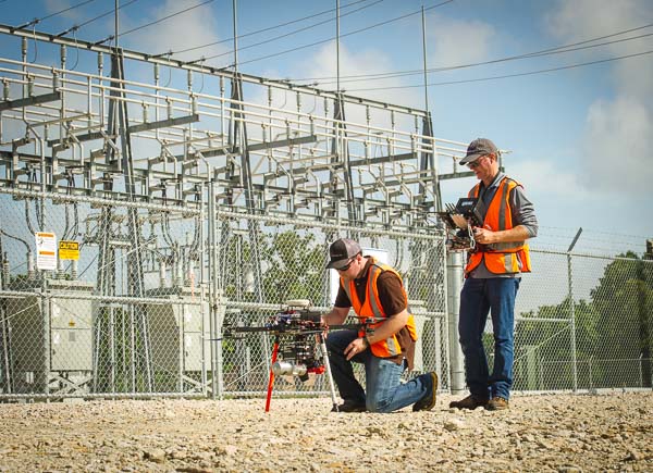
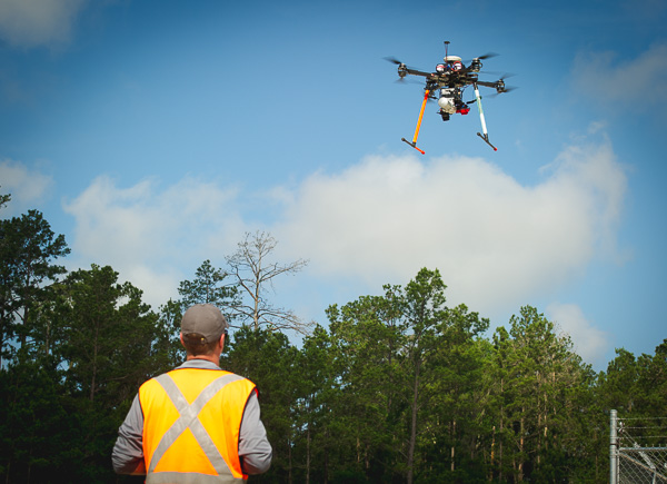
McCord Engineering’s unmanned aerial services reduces the amount of time it takes for our clients to access the information they need. Data that once took days to obtain through traditional survey and inventory methods is now gathered in a matter of hours with greater accuracy and far more detail utilizing an unmanned aerial vehicle (UAV). Using a UAV platform for data collection sensors and high-resolution cameras provides a vantage point for the most complete information and imagery available, and it is not subject to the same limitations in access as ground-based data collection. MEI partners with a team of experienced utility industry professionals and FAA licensed pilots, dedicated to applying state-of-the-art technologies to produce high-quality deliverables for our clients. Our objective is to provide highly refined and accurate data to our clients about their facilities in the field in order to support specific business decisions and objectives. While many other firms are working toward diversifying their services across multiple industries, MEI is focused on developing the best possible services and resources for the electric utility industry.
Current UAV Platforms
- TDP-X8
- Helicopter UAV
UAV Sensors
- LiDAR
- FLIR Infrared
- 4K Video
- High Resolution Still Cameras
- Normalized Difference Vegetation Index (NDVI)
In most cases, all sensors can collect data simultaneously in one flight. This creates a series of data that can be used for many different applications.
Common UAV Applications:
Powerline Engineering / NERC Compliance
The data collected from our multiple sensors paints a great picture of what is actually out in the field. The combination of LiDAR and data from our on-site weather stations creates a very accurate model of existing attachment heights and sag conditions of conductors. Once this information is integrated into our PLS-CADD design software, the result is the most accurate powerline engineering product at a very economical rate to our clients.
Vegetation Management
The UAV team uses a combination of LiDAR, images, video and NDVI cameras to gather the data necessary to run a highly accurate vegetation analysis. With this data, we can determine fall-in and grow-in violations, height of vegetation, identify dead or unhealthy trees and more.
System Mapping
With a combination of sensors, the UAV team can map or update mapping on existing powerline systems. These techniques allow us to obtain precise coordinates of pole locations and gather asset information through images and video. The collected information can also be used to obtain communication attachment data.
Substation Surveys
By gathering data with using the LiDAR sensor, FLIR, and high-resolution cameras, we are able to deliver valuable as-built information to our customers. If you are planning a new substation, the UAV team can gather centimeter-grade survey data to assist in site design.
Utility Structure Inspections
The UAVs are equipped with FLIR infrared and high-resolution imagery provide our team with the necessary data to perform a quality visual inspection of facilities. This approach results in a safer work environment completed at a lower cost than traditional means.
Communication Tower Inspections
Traditionally, towers are inspected by climbing the structures and taking photos and notes along the way. With today’s technology, we are able to collect high-definition images and video as well as LiDAR and infrared. This creates a much safer environment with more accurate data. We can deliver this data in user-friendly viewing software. Imagine a georeferenced map showing all tower locations; inside each tower location, you can view and measure the most up-to-date data at each location.
Disaster Management
In the event of a disaster, MEI ready to help assess the situation and deliver the results in a timely manner through our partnership with experienced UAV pilots. UAVs are capable of collecting photos/video feeds and broadcasting real-time information back to a command center. This helps expedite the remediation process and provides information for media outlets and critical insurance documentation. UAVs and the sensors mounted on them work for a number of other applications, including:
- Proposed Corridor Surveys
- Pipeline Right-Of-Way Inspections
- Photo/Video Shoots
- Construction Site Inspections
- Insurance Inspections
- Volumetric Surveys
- Topographic Surveys
- As-Built Surveys
For more information about Unmanned Aerial Services, contact Rex Woods.
What Our Clients Have to Say…
McCord Engineering started providing work order inspections prior to 1989 and our relationship with McCord Engineering has grown to being our main engineering firm doing two year and long range work plans, sectionalizing studies, designing and inspection of transmission upgrades, and designing distribution work plan projects. We have found McCord Engineering to be very competent and innovative group using the latest technology such as lidar drones to survey and design distribution lines and assist us with any needs.
Clayton Stanford
Engineering Director
San Bernard Electric Co-op
McCord Engineering is one of the most innovative, forward looking, and technologically advanced consultants Mid-South Synergy have had the privilege to work with. We are proud to have them work with us on our Vegetation Management program using LIDAR and multispectral imagery, an approach that has changed the way we do vegetation management and has the potential to change the utility industry as a whole….
Dr. Comfort Manyame
GISP
MidSouth Synergy
McCord has provided Engineering services to the City of Georgetown since 1988. They are reliable, accurate, and responsive to all our needs and willing to go the extra mile in our behalf.
Jimmy L. Sikes
Electric Engineering Manager
Georgetown Utility Systems/Electric Division
McCord Engineering has been a tremendous resource for CoServ Electric since 1996. When we work with McCord, we are collaborating with engineering experts who are extremely knowledgeable, reliable and responsive to our needs and those of our Members. They consistently use cutting-edge technology and innovative practices to provide a quality product that is complete and efficient. Our track record with them is excellent, and they always commit the resources, time and talent to make our relationship a win-win.
Chris Skidmore
Manager of Major Designs and Standards | Engineering Services